|
District NRDMS Center,
Vijayanagara
O/o Zilla Panchayath Vijayanagara,
T B Dam Road Hospete,
Vijayanagara District- 583225
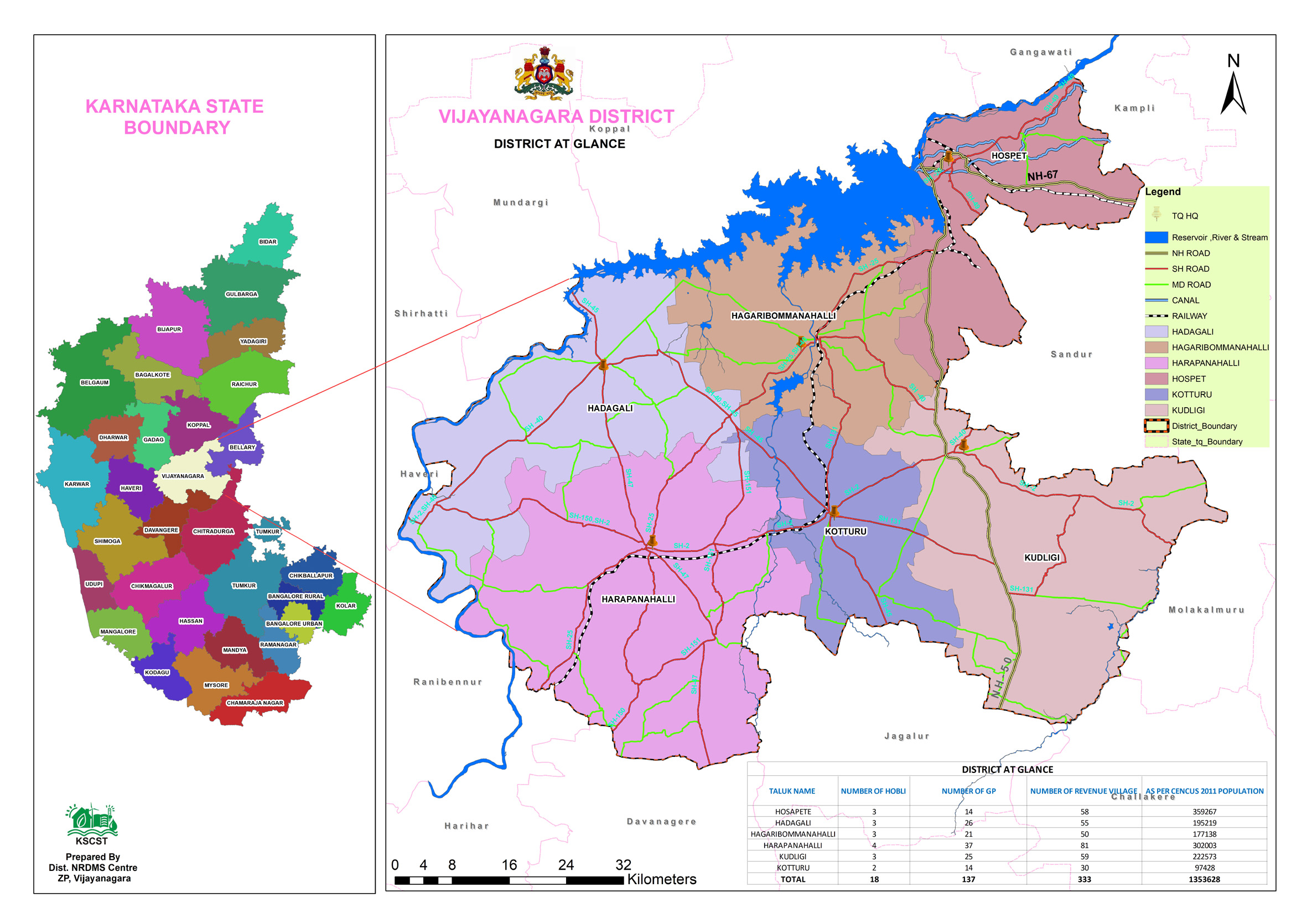
Introduction
The
Vijayanagara district NRDMS Centre was established
in the year 2021-2022
at Office of the
Vijayanagara
Zilla Panchayath
with financial support from Department of Science and
Technology, Government
of India, Implemented by K.S.C.S.T, Bangalore with active
support from Department
of Science &
Technology, Government
of Karnataka. The main objective of the centre is to create
the digital database on Natural resources, Demography, Agro &
Socio economy and infrastructure facilities of the
District to provide analysed information to the district
administrators, Zilla panchayath, line departments, Academic
institutions and NGOs in Natural resources management and
rural development planning with the help of GIS and
other advanced scientific technologies.
Activities carried
out at District NRDMS Centre
-
The primary
objective of District NRDMS Centre under NRDMS Project is to
create Extensive database on Spatial Database (Maps) and Non-Spatial
Database (Attribute data) of Natural Resources, Socio & agro-economic
parameters and Infrastructure facilities of the district
after collating from the line departments and other
organizations and it is been updating regularly based on
nature of availability of data and requirements.
Tourism Location Mapping, Vijayanagara District: Collected
data from DEO, DC Office and prepared GIS-based tourism
location maps using ArcGIS.
Human Development and Asset Mapping: Prepared theme-wise
maps for Human Development Indicators (standard of living,
education, health, HDDI) and asset mapping for Malapanagudi
Gram Panchayat
Police Jurisdiction and Accident Zone Mapping, Vijayanagara
District: Prepared GIS-based maps of police sub-divisions,
circles, police station jurisdictions, and accident zones
Health Facility Mapping: Prepared GIS-based pictorial and
public health facility maps for the district to support
planning and management by the Health Department.
Roadside Plantation Mapping: Provided technical assistance
to update roadside plantation data in the KGIS Portal for
the Forest Department.
Excise Jurisdiction Mapping: Prepared GIS-based excise
jurisdiction map for the Hospet Excise Division.
Proposed Road Mapping: Prepared maps of proposed PRED and
PWD roads using Google Earth.
Activity Report for the
Month April - July 2025
Activity Report for the Month August - November 2025
Activity Report for the Month December 2025 - March 2026
* ~ * ~ *
|