|
District NRDMS Center,
Vijayapura
O/o Vijayapura Zilla Panchayath, Vijayapura District - 586103
Introduction
The
Vijayapura
district NRDMS Centre was established in the year
1993-1994
at Office of the Vijayapura
Zilla Panchayath with financial support from Department of
Science and Technology, Government
of India, Implemented by K.S.C.S.T, Bangalore with active
support from Department
of Science &
Technology, Government
of Karnataka. The main objective of the centre is to create
the digital database on Natural resources, Demography, Agro &
Socio economy and infrastructure facilities of the
District to provide analysed information to the district
administrators, Zilla panchayath, line departments, Academic
institutions and NGOs in Natural resources management and
rural development planning with the help of GIS and
other advanced scientific technologies.
Activities carried
out at District NRDMS Centre
-
The primary
objective of District NRDMS Centre under NRDMS Project is to
create Extensive database on Spatial Database (Maps) and Non-Spatial
Database (Attribute data) of Natural Resources, Socio & agro-economic
parameters and Infrastructure facilities of the district
after collating from the line departments and other
organizations and it is been updating regularly based on
nature of availability of data and requirements.
-
The NRDMS
Centre has been assisting the District administration, Zilla
Panchayath, line departments, NGO's
and Academic institutions by providing analysed information
in the form of maps, graphs, charts and technical reports
which are self-explanatory and more informative based on the
requirements.
-
The NRDMS
Centre also assists District administration in preparing
Legislative and Parliamentary Assembly Constituency wise
Location and Jurisdiction of Polling stations with Numbers
and type of polling booths along with route maps to carry
polling personnel and materials as required by DC to be
submitted to Election commission and Observers.
-
Preparation of
updated maps on Rainfall, Crops, Ground water table in
comparison with previous years and Drinking water facilities
as required by District administration.
-
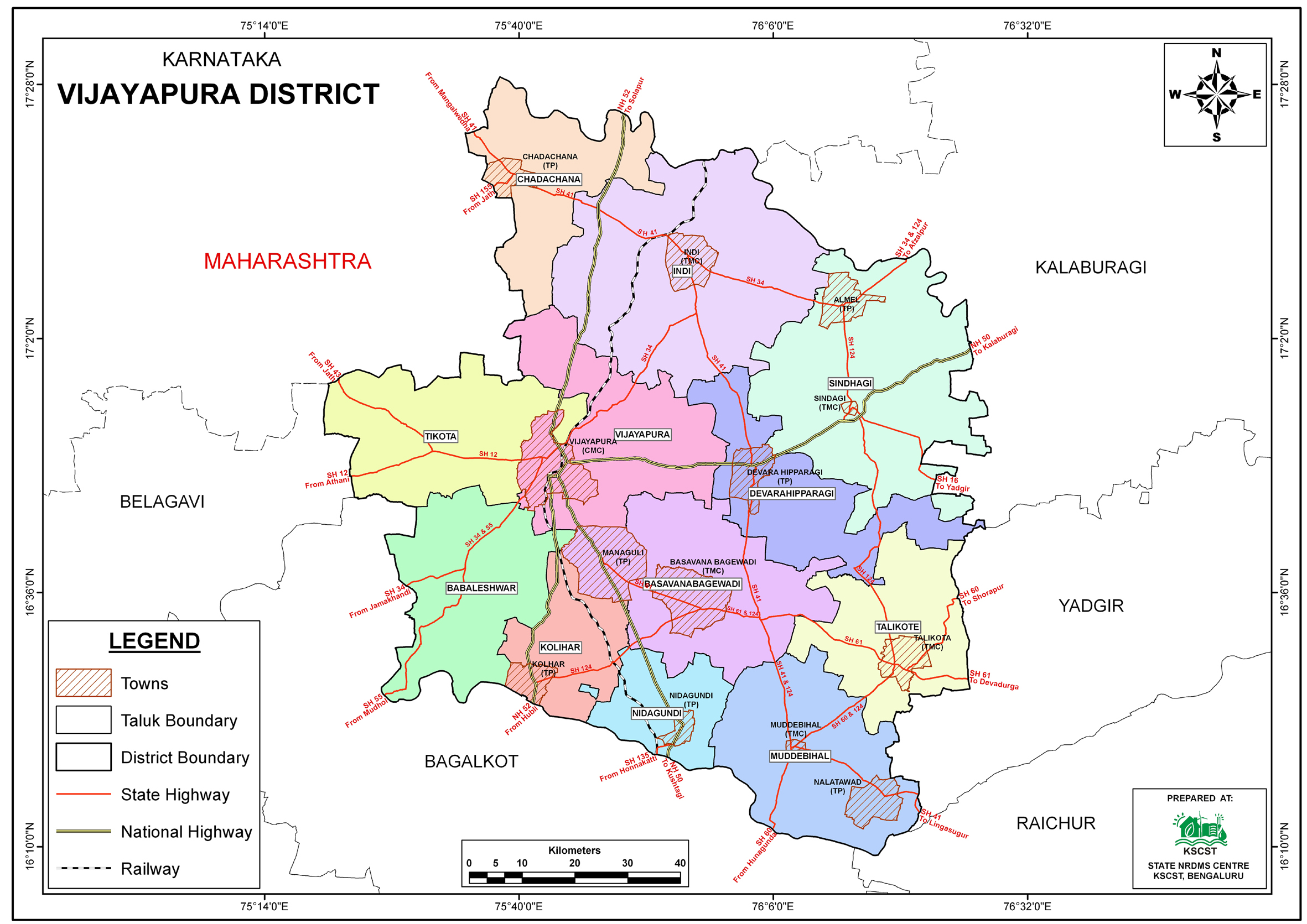
A major
activity involved the preparation and finalization of
detailed, Taluk-wise Grama Panchayat (GP) maps for the
Vijayapura District.
-
Maps
were generated for twelve taluks, including Vijayapura,
Babaleshwar, Almel, Chadachana, Devara Hipparagi, Indi,
Kolhar, Nidagundi, Talikote, Muddebihal, Tikota, and
Basavana Bagewadi.
-
The locations
of administrative centers were marked, specifically the
Taluk Head Quarters, GP Head Quarters, and Village Locations
.
Activity Report for the
Month April - July 2025
Activity Report for the
Month August - November 2025
Activity Report for the Month December 2025 - March
2026
* ~ * ~ *
|