
|
|
|
|
|
|
||
|
|
||||||||||||||||||||||||||||||||||||||||||||||||||||||||||||||||||||||||||
|
Karnataka Geoportal System Architecture
|
Karnataka State Spatial Data Infrastructure (KSSDI)
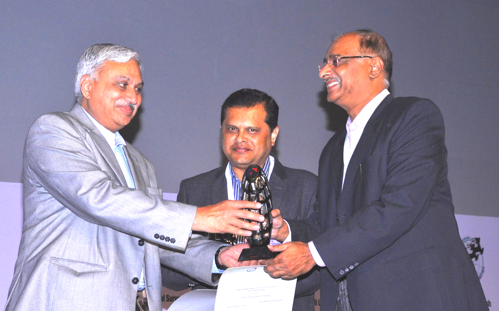
Karnataka State Spatial Data Infrastructure (KSSDI) was awarded Geospatial Excellence Award for the year 2014 for establishing a citizen centric KSSDI portal and for effectively disseminating geospatial information to all users. This was awarded at India Geospatial Forum 2015 event held on 10th February 2015 at Hyderabad. Dr. Shailesh Nayak, Secretary, Ministry of Earth Sciences, Government of India gave away the Certificate and memento to Shri H. Hemanth Kumar, Principal Investigator, KSSDI Programme & Dr. M. Prithviraj, Executive Secretary, Karnataka State Council for Science and Technology (KSCST). The award is given to KSCST and DST-GOI.
● To develop a web based Geo Portal to acquire, process, store, distribute and improve the utilization of geo spatial data. ● Data clearing house which would be a gateway of spatial data being generated by various agencies in the State.
Under a joint project of Natural Resources Data Management System (NRDMS) of Department of Science & Technology, Government of India, and the Government of Karnataka, Karnataka State Council for Science & Technology (KSCST), Bangalore has developed district level GIS databases to support the process of Local Level Planning at the levels of district, taluk and village. Each District Database contains spatial and attribute data sets useful in local level planning processes in the sectors of Natural Resources, Demography, Agro-economy, Socio-economy and Infrastructure facilities. Respective Zilla Panchayaths and Line Departments have been depending upon the databases for meeting their data requirements. Over the past one and a half decade all the twenty nine districts of Karnataka State have been covered under NRDMS. With increasing dependence of the Zilla Panchayaths/Urban local bodies, Line Departments and other stake-holders of local level planning on spatial datasets, a need has been felt to speed up the process of discovery of and access to up-to-date spatial datasets.
The Karnataka state has a rich "base" of map information in digital format at district level generated/created by various national/state government organizations through topographic surveys, geological surveys, soil surveys, cadastral surveys, various natural resources inventory programmes and the use of the remote sensing images. Now, with the availability of precision, high resolution satellite images, data enabling the organization of GIS, combined with the Global Positioning System (GPS), the accuracy and information content of these spatial datasets or maps is extremely high. Encapsulating these maps and acquired images and provided by various organizations including government, academic and private sectors in Karnataka into a organized repository and provide access to all users for various developmental needs is the need of the hour. There are new innovative ways of technological innovation in allowing us to capture, store, process and display an unprecedented amount of valuable geographical and spatial information about Society and a wide variety of environmental and cultural phenomena. It is the vision of National Spatial Data Infrastructure (NSDI) that current and accurate spatial data must be readily available to contribute to local, state and national development and contribute to economic growth, environmental quality and stability, and social progress. The emphasis is made on information transparency and sharing, with the recognition that spatial information is a national resource and citizens, society, private enterprise and government have a right to access it, appropriately. Only through common conventions and technical agreements, standards, metadata definitions, network and access protocols will be easily possible for this vision to come into existence. In realizing the vision of NSDI and requirements of various state government agencies, Karnataka state through Karnataka State Council of Science and Technology (KSCST) has decided to establish the state level spatial data infrastructure. The Council with the support DST-GoI and DST - GoK initiated to develop a Geoportal and Data Clearing House to discover/ access spatial data sets useful in the local level planning process through Karnataka State Spatial Data Infrastructure (KSSDI) Project. The geo-portal is expected to serve as a centralized hub for other spatial data generating agencies in the State. Web-enabled centralized database of various existing spatial, attribute or statistical data has been generated at KSCST, Bangalore.
Karnataka State level Spatial Data Infrastructure (KSSDI) called Karnataka Geoportal is a centralized single window access mechanism for all the spatial data acquired by various agencies in Government of Karnataka using State's resources primarily to support planning activities of the Panchayath Raj Institutions (PRIs), district/state line departments, Urban Local Bodies (ULBs) and civil society organizations in the State. KSSDI is an Internet based GIS Directory for the state that eventually will be extended for the use of the society in exploring the information related to state geography, demography, agro and socio economy, and infrastructure facilities. Spatial datasets generated, maintained and provided by various concerned Line Departments of the State Government, academia, private or civil society organizations of Karnataka are proposed to be made accessible through the project data clearinghouse mechanism. In the future the site can also be extended to cater to sale and purchase of data online. All the data would be shared through the Open GIS Consortium (OGC) recommended standards. The available data would be catalogued and the search for availability of any particular dataset would be made available through specially customized metadata (data about the data) utility. In this architecture, KSSDI Gateway and its user interface allow a user to query distributed collections of spatial information through their metadata descriptions. This spatial information may take the form of "data" or of services available to interact with spatial data on the different data server, described with complementary forms of metadata. A user interested in locating spatial information uses a search user interface, fills out a search form, specifying queries for data with certain properties. The search request is passed to the database Server, which shall search the Metadata repository on its end. The datasets fulfilling the search criteria will be displayed to the user, on users request the same can be accessed from the Agency Server. The KSSDI Data clearing house and geo-portal would act gateway for various data generating agencies to share the information across various government departments, NGOs, academies, industries and scientific organisation. It will be a Single window system for discovery, view and access state geo-spatial data sets along with attributes. The individual departments and KSCST would be able to add and update the state geo-spatial data sets thereby providing the up-to-date spatial data dictionary and map directory for the state and facilitate decision support system and helps in local level planning. Thus, KSSDI would provide scientific approach to the decision makers, planners and administrators to facilitate common man usage of valuable Geo-spatial data. Also, the proprietary data prepared by department can also be used for the data sale and purchase, which can be part of the state revenue generation. The complete KSSDI portal is developed using the ERDAS Apollo Software, an OGC compliant with facilities to share the vector and raster datasets through WMS, WFS and WRS web services along with the solutions and products from IBM for server hardware, storage, backup and retrieval systems, CISCO for the Networking components and Oracle for RDBMS requirements, respectively.
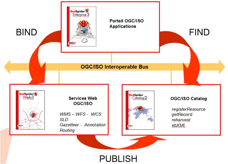
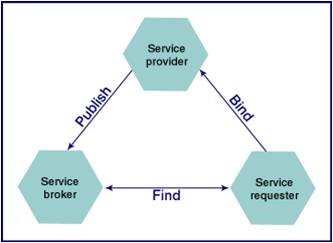
KSSDI – Service Oriented Architecture There are a large number of users interested in the visualisation and analysis of the data organized and maintained by different sources, without having to install the specific applications or data on their terminals. They want to be able to connect to data services in real time and create different data combinations, and ultimately publish / share the contents and services to third parties and application developers. This goal is possible with the help of Service Oriented Architecture (SOA) applied to spatial information. An SOA can be implemented with Web services. Web services consist of XML based transport protocols and open standards designed to exchange data between different applications. Software developed and written in different programming languages for different platforms can all use Web services to exchange data using the Internet and HTTP protocol. This interoperability is made possible by the use of open standards. One of the key elements of an SOA is the Service Registry: a record and description of all available services. It allows users not only to find and discover which services could be useful in providing solutions to their needs but also to integrate them into their business applications. The methodology can thus be described as follows: ● service providers; set up Web Services ; ● they then publish these Web Services in the service registry : < publish >; ● < consumers / users > then discover these services by means of queries… < find > ; ● … and integrate them into their applications < bind > ; Service Oriented Architecture, implemented by means of Web Services is particularly useful for setting up spatial data infrastructures for geographic information systems. The SDI provide the means for regulators, planning committees, managers, individuals and their organisations to discover, access and use spatial data.
The basic components of KSSDI are: ● Content storage: geographic data, i.e. Local alphanumeric data, data models and associated documentation, metadata ; ● Geographic data Library ; ● Business processing services : < geo-services > for the purpose of, for example : ◊ accessing data ; ◊ finding both data and services ; ◊ sharing toponymic indexes ; ◊ webmapping queries ; ◊ coordinate transformation services ;
◊ finding
the quickest path ;etc.
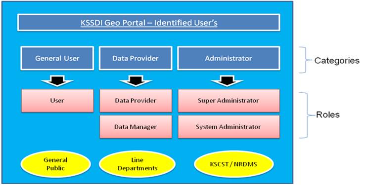
In line with the SOA, the users of the KSSDI Geo Portal are classified into three main categories: a) General User: Any internet user/ General public wanting to access the portal must register (sign up) online to access the map services. b) Data Provider: User or representatives from the State or District level Line Departments, and District NRDMS centres participating in the data sharing with KSCST or members within KSCST itself. This user group based on the roles and privileges is sub-categorized further into two: Data Provider and Data Manager. Data Provider: Will be representing their respective line departments and are authorised to make changes to the data pertaining to their department only. Data Manager: Will be a member of the KSCST staff who is authorised to perform overall data operation across all departments under the guidance of the Administrator of the KSSDI system. c) Administrator: The administrator is considered as the super user of the system with the sole privileges to administer the complete system. They are further sub categorised as: System Administrator and Super Administrator System Administrator - who is an authorised KSCST staff to perform administrative operations of the system that includes Managing Users, Roles and Privileges, application resources, system auditing and reports. Super Administrator: who has the sole authority over the system setup and its resources. He would be responsible for the data uploaded/update, modification of data format, define/modify and managing privileges for all user groups, administrative user profile, login, IP, security etc. The overview of the user categorisation is given below:
FUNCTIONS OF KSSDI GEOPORTAL KSSDI Geo Portal provides an OGC framework for accessing spatial data across organizations or group of users in an efficient and flexible manner. This has the following components : I. Map Viewer is an internet based interactive map viewing applications, which allow a user to view the spatial data. Map Viewer also facilitates map discovery, querying, analysing and update. II. Map Catalogue is list of map services available as a map directory. It allows the user to browse the directory of spatial datasets that are available as map layers. It facilitates an authorized data provider to publish map data as service that can be accessed remotely. III. Metadata is information about spatial data. This would enable a user ton view the descriptions of the metadata before actually accessing/working with the data. The authorised users would be able to Create, Update, Remove and Export Metadata is provided. IV. Product Catalogue: facilitate spatial datasets as maps to be listed as products and hosted for online sale and purchase with the payment details. Registered users can search for map products, select and download by making online transaction. V. Service Request: allows users to post their requests via the portal to publish data as map services or make available as a product. The request can be made to the KSSDI Administrator or to a specific Line Department. VI. KSSDI Applications: KSSDI Applications are prepared based on the currently identified needs of the line departments. The applications are categorized based on the department name or a search keyword. These applications will help the Users in taking decision making process. A indicative list of application requirements are given below which would be available as part of KSSDI Geoportal for various users.
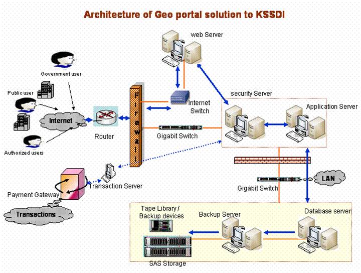
The diagram provides a schematic representation of the infrastructure and network requirements to host the Geo Portal and the clearing house and provide the system performance as stated in the requirements. The diagram also show required number of servers, and server types, and how these servers will communicate with existing infrastructure and partner systems.
IBM provides the HS21 blade servers for the 5 servers viz, web, security, backup, database and applications servers. The industry-leading flexibility, performance, and investment protection you've come to expect from the IBM servers has been extended even further with the introduction of a new generation of 2 processors, which run at clock speeds as high as 3.3 GHz and are available with a Level 2 cache as large as 6MB. The Oracle 11g Enterprise Edition along with the Spatial Option gives the industries best RDBMS solution. Oracle Database server with spatial option is an OGC compliant product for storing Spatial and metadata. The unique features of Oracle in storing, retrieval adds value to our solution to KSSDI. The Virtual private database and data encryption adds more to the existing security features. The Geo-portal solution as per the requirements of KSSDI / KSCST would have a total of 5 servers as shown in the architecture. The LDAP - active directory would be housed in the security server, along with the security module developed for the web portal. Security features will be compatible with LDAP (Light Directory Access Protocol) and Microsoft's Active Directory, and would enable the establishment of a single sign-on security and authentication scheme. The application server would be housing the web portal solution, OGC certified WMS, WFS, WRS web services. The portal would also be housing the data conversion software / utilities. The Geo-Portal is also expected to have an transaction module which keeps account of the various transactions. The transaction services is later planned to be connected to a payment gateway of any of the nationalized bank like State Bank of India for payment transactions. The KSSDI portal passed preliminary stage of development and was released to users during October, 2009 for portal functionality testing. The release allowed the testing of the portal to undergo usability testing with selected users who provided feedback to the project team. Identified malfunctions were rectified. The Council officially launched Karnataka GeoPortal during December, 2009 at the 9th annual event of National Spatial Data infrastructure by the Honourable Minister of State for Science & technology, GOI, Sri. Prithviraj Chavan. The Council is initiating to set up state level committee to sensitize various departments/agencies of the government of Karnataka on the concept of SDI and the utility of Geo-portal and clearing house in order to secure their cooperation in the utilization/development of portal. The complete Karnataka Geo Portal is developed using the ERDAS Apollo Software, an OGC compliant with facilities to share the vector and raster datasets through WMS, WFS and WRS web services along with the solutions and products from IBM for server hardware, storage, backup and retrieval systems, CISCO for the Networking components and Oracle for RDBMS requirements, respectively. It is a centralized single window access mechanism for all spatial data acquired by various agencies of the state. The Karnataka Geoportal has been continuously being fine tuned for some of the issues like search feature enhancement, usability issues, application queries rectification and functionalities. The portal also has long list of pre canned queries for different type of users as well as the facility for user defined queries. Training of the project staff as well as district project personnel has been completed. Cataloguing of various data/metadata services available in Karnataka Geoportal has already been taken up and with increasing user awareness, the State will have to frame a policy/ guideline for dealing with user requests for getting access to feature or map data. An open approach at this stage with governmental stakeholders will facilitate better user awareness and promotion of the use of the standardised data sets/ services in governance-related activities. This in turn will help upgrade value of the data/ services for their better marketability amongst stakeholder agencies. Participation of state level departments/directorates has facilitated in arriving suitable modalities for the data/ metadata using the geospatial tool developed under the project. The KSSDI Steering Committee has also triggered the issue of data sharing as well as data updation process. Under this project a meeting of the stakeholders from the Government sector at State level was held to deliberate on issues related to: 1. Online data sharing / updation mechanism 2. Metadata/Catalogue of services of participating agencies 3. Data standardisation for interoperability 4. Data sharing policy
Karnataka GeoPortal is envisaged to be a centralized single window access mechanism for all spatial data held and acquired by various agencies/line departments of the state. The modules in the Karnataka Geoportal are categorized into : ● Map viewer - Web Map Service (WMS), ● Product catalogue/metadata - Catalogue Service on Web (CS-W), ● Services specific service/ feature data sets - Web Feature Service (WFS), ● Simple Applications (Query based decision support) ● Coverage services/images - Web Coverage Service (WCS) ● Help/support Karnataka Geoportal URL: www.karnatakageoportal.in
User acceptance testing (UAT) is the last phase of the portal/ software testing process. During UAT, actual portal was tested to make sure it can handle required tasks in real-world scenarios, according to specifications with the support of State and district NRDMS centre staff, Experts from IIT - Bombay and IISc. The portal was made available for a trial for the both the in-house testing team and other experts. Following are the steps involved in in-house UAT: ● Planning: The UAT strategy was adopted by the advice of experts from IIT- Bombay. ● Designing test cases: Test cases are designed to cover all the functional scenarios of the software in real-world usage. The access and discovery of data was an important bench marking for testing the portal. They were designed in a simple language and manner to make the test process easier for the testers. ● Selection of testing team: The testing team comprised of real world end-users. ● Executing test cases and documenting: Majority of the test cases were documented and tested randomly for bugs. ● Bug fixing: Responding to the bugs found by the in-house testing team, the vendor made few adjustments to the code to make the portal relatively bug-free.
1. Development of web based geospatial applications for Karnataka Watershed Development Department for monitoring and evaluation of IWMP projects and health sector. 2. Institutional mechanism for Karnataka Geoportal to facilitate spatial datasets from concerned Line Departments to the monitoring, evaluation and formulation of developmental programmes/ schemes in watershed and health sectors. 3. Data sharing by data generating agencies through Karnataka Geoportal 4. Development of multi-lingual search facility 5. Integration of Ortho-images on geospatial applications for visualization 6. Map comparison tool for assessing the quality of crowd-sourced data 7. Crowd sourcing of points of interest in Karnataka Geoportal
Screenshots of KSSDI Geoportal
| |||||||||||||||||||||||||||||||||||||||||||||||||||||||||||||||||||||||||
|
| ||||||||||||||||||||||||||||||||||||||||||||||||||||||||||||||||||||||||||
|
|
|
|||||||||||||||||||||||||||||||||||||||||||||||||||||||||||||||||||||||||
| This page was updated on : 28 August 2020 02:33 PM | ||||||||||||||||||||||||||||||||||||||||||||||||||||||||||||||||||||||||||